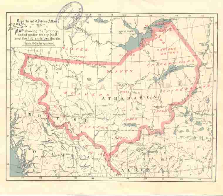
"Map showing the Territory ceded under Treaty No. 8 and the Indian tribes therein - 1900"
 | ||
| Database ID | 25205 | |
| Institution | University of Saskatchewan Libraries Special Collections | |
| Fonds/Collection | Canadiana Pamphlets Collection | |
| Series | Map617 | |
| File/Item Reference | Map617-fhg-1900 (Map617a 1900) | |
| Date of creation | 1900 | |
| Physical description/extent | 1 map; colour; 21 cm x 26 cm | |
| Number of images | 1 | |
| Scope and content | Map published by the Canadian Department of Indian Affairs showing territory ceded under Treaty 8 and the First Nations living therein. | |
| Restrictions on access | There are no restrictions on access. | |
| Contributer | Department of Indian Affairs (author) | |
| Copyright holder | Public domain | |
| Copyright expiry date | Public domain | |
| Other terms governing use and reproduction | Responsibility regarding questions of copyright that may arise in the use of any images is assumed by the researcher. | |
| Type | Archival | |
| Primary Media | Textual documents | |
| Provenance Access Point | University of Saskatchewan Library. Canadiana Pamphlets Collection | |
| Other notes | Scale: 100 miles to an inch. | |
| Treaty boundaries | Treaty 8 | |
| Cultural region | Plains | |
| Names | Department of Indian Affairs | |
| Subject | Crown Lands Government departments -- Indian Affairs Reserves Treaty -- Treaty 8 Maps | |
| Date Range(s) | 1900-1909 | |
| Permanent Link | https://digital.scaa.sk.ca/ourlegacy/permalink/25205 |
|