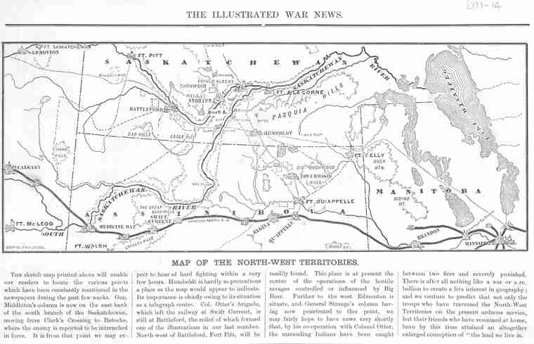
Map of the North-West Territories - Newspaper clipping. - [1885?].
 | ||
| Database ID | 24380 | |
| Institution | University of Saskatchewan Libraries Special Collections | |
| Fonds/Collection | Canadiana Pamphlets Collection | |
| Series | LXII | |
| File/Item Reference | LXII-14-MapOf (LXII O/S drawer) | |
| Date of creation | [1885?] | |
| Physical description/extent | 1 newspaper clipping; b&w; 14.5 cm x 25.5 cm | |
| Number of images | 1 | |
| Historical note | First printed in The Illustrated War News, 1885. | |
| Scope and content | A map of the North-West Territories and brief story focusing on the Districts of Saskatchewan and Assiniboia in 1885. Below the map is a brief explanation of places in relation to the Northwest Resistance. The map was apparently published shortly before the Battle of Batoche as it reports "Middelton's column is now on the east bank of the south branch of the Saskatchewan, moving from Clark's Crossing to Batoche, where the enemy is reported to be entrenched in force." | |
| Contributer | Illustrated War News | |
| Copyright holder | Public domain | |
| Copyright expiry date | Public domain | |
| Other terms governing use and reproduction | Responsibility regarding questions of copyright that may arise in the use of any images is assumed by the researcher. | |
| Type | Archival | |
| Primary Media | Photographs | |
| Provenance Access Point | University of Saskatchewan Library. Canadiana Pamphlets Collection | |
| Treaty boundaries | Treaty 4 Treaty 6 Treaty 7 | |
| Cultural region | Plains | |
| Names | Big Bear, ca. 1828-1889 (Chief) Illustrated War News Middleton, Frederick Dobson, 1825-1898 mistahi-maskwa Otter, William Dillon, 1843-1929 Strange, Thomas Bland, 1831-1925 (General) | |
| Subject | Northwest Resistance Warfare Geography -- Maps and Borders Aboriginal Military | |
| Date Range(s) | 1880-1889 | |
| Permanent Link | https://digital.scaa.sk.ca/ourlegacy/permalink/24380 |
|